Skip to content
HOME
ABOUT
SERVICES
CONTACT
HOME
ABOUT
SERVICES
CONTACT
Grant Resources
Grant Resources
Waitlist_Appalachian Regional Commission
Economic Development Administration
Intergovernmental Review Process
Waitlist_Appalachian Regional Commission
Economic Development Administration
Intergovernmental Review Process
Training
Training
Evening Training
Regional Leadership Conference
Evening Training
Regional Leadership Conference
Publications
Mapping
“Serving Chemung, Schuyler and Steuben Counties”
Categories
Tags
Publications
North Hornell: Levee and Approximate Protected Area
Source: National Levee Database
Category:
Levees
Tags:
Map
;
Steuben County
File Name: NorthHornell_LeveedArea.png
Size: 0.11 MB
Modified: 08/02/2017
Preview
Download
Bath: Levee and Approximate Protected Area
Source: National Levee Database
Category:
Levees
Tags:
Map
;
Steuben County
File Name: Bath_LeveedArea.png
Size: 0.27 MB
Modified: 08/02/2017
Preview
Download
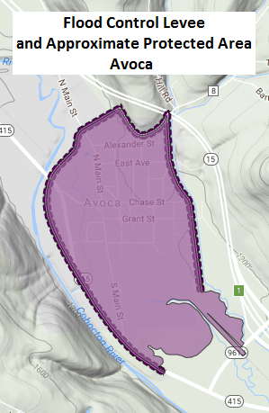
Avoca: Levee and Approximate Protected Area
Source: National Levee Database
Category:
Levees
Tags:
Map
;
Steuben County
File Name: Avoca_LeveedArea.png
Size: 0.10 MB
Modified: 08/02/2017
Preview
Download
Montour Falls: Levee and Approximate Protected Area
Source: National Levee Database
Category:
Levees
Tags:
Map
;
Schuyler County
File Name: MontourFalls_LeveedArea.png
Size: 0.15 MB
Modified: 08/02/2017
Preview
Download
